For centuries, Humans have been trying to find ways to know their position as accurately as possible, in various and varied fields such as navigation, exploration of the planet and nowadays in the universe, geolocation by satellite. A particularly effective method is trilateralisation.
The search for a positioning technique according to reference points dates back to antiquity. Used by the Greeks and Egyptians, similar methods made it possible to map territories, measure the distance between cities. Thus, ancient peoples located themselves with the help of landmarks such as Cumes near Naples, Lilybea in Sicily and Cape Malaeus in Peloponnese. Subsequently, advances in mathematics and geometry allowed the improvement of this method.
In the 1960s, trilateration gained momentum following the emergence of satellites and positioning systems such as GPS at the heart of our smartphones and cars allowing us to access their position in real time.
How does this method work?
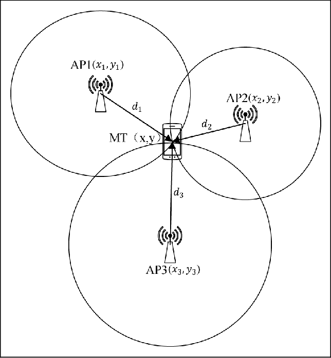
In the case of a point located at unknown coordinates but at known distances from three reference points and known coordinates, the following steps make it possible from the trilateration to determine the exact position of the object.
- Draw a circle around the first landmark that can be a rock, a monument or a city such that the point of unknown position is on the circle drawn.
- Do the same with the second reference point. The two circles cut at two possible points.
- Do the same with the third point, eliminating one of the two points and indicating the exact location.
This technique can be replicated with spheres, a technique used by smartphones, satellites and GPS.